Satellite Propagation Delay Calculator
Estimate satellite one-way delay, RTT, slant range, uplink and downlink legs, bent-pipe hops, and processing allowance for LEO, MEO, and GEO links.
| Orbit profile | Altitude | Zenith one leg | 45 degree slant | One bent-pipe RTT |
|---|---|---|---|---|
| LEO | 550 km | 1.83 ms | 2.43 ms | 9.7 ms |
| Method | Best use | Input that matters | Output behavior |
|---|---|---|---|
| Elevation angle | Terminal to visible satellite | Altitude and elevation | Computes equal uplink and downlink slants |
| Ground distance | Gateway to user via midpoint satellite | Altitude and terminal spacing | Splits the central angle across both legs |
| Manual slants | Measured or externally modeled link budget | Uplink and downlink slant ranges | Uses entered leg lengths directly |
| Link profile | Typical orbit | Hop count | Processing allowance | Planning note |
|---|---|---|---|---|
| Transparent bent-pipe VSAT | GEO | 1 | 1 to 5 ms per hop | Main latency is propagation, not onboard processing. |
| Regenerative payload | LEO or MEO | 1 to 2 | 5 to 20 ms per hop | Onboard routing or packet handling can matter. |
| GEO double hop | GEO | 2 | 2 to 10 ms total satellite allowance | Often appears in hub-to-hub or legacy relay paths. |
| LEO gateway internet | LEO | 1 | 3 to 15 ms terminal and gateway | Terrestrial backhaul and queueing usually dominate after RF. |
| Preset | Orbit | Geometry | Hops | Use case |
|---|---|---|---|---|
| LEO Broadband | 550 km | 45 degree elevation | 1 | Consumer internet access with gateway backhaul. |
| MEO O3b Style | 8063 km | 55 degree elevation | 1 | Enterprise trunk or island backhaul planning. |
| GEO VSAT Internet | 35786 km | 35 degree elevation | 1 | Remote site internet through a geostationary satellite. |
| GEO Double Hop | 35786 km | Manual slants | 2 | Legacy relay where traffic crosses two satellite hops. |
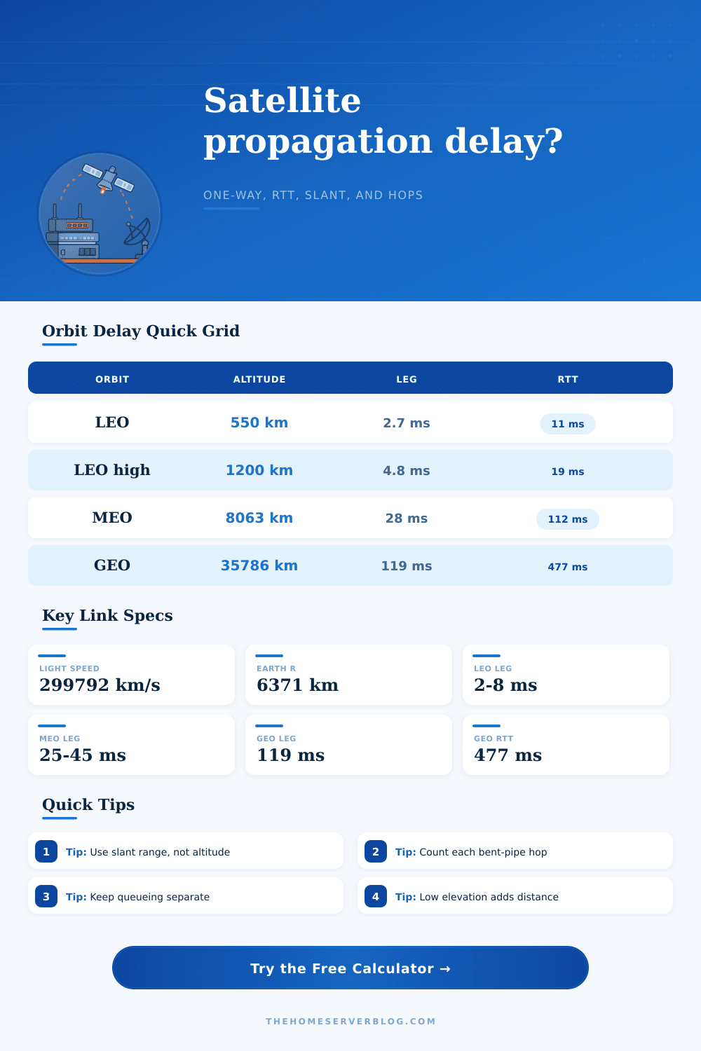
Light moves fast. Realy fast. It complete a lap around globe 7.5 times every second. But if you make video call to someone through geostationary satellite, there’s lag. By the time you say hello, the delay have already happened. There’s no “bug,” just physics demanding its own terms. You can’t negotiate with distance from orbit.
This all goes back to path length. People wrongly believe “altitude” means “distance,” so when they see satellite at 550 kilometers, they believe their signal is traveling 550 kilometers. If you’re right underneath the satellite then yes, it’s travelling that far. But for most consumer dish, this never occurs. Instead, the signal follow what’s called a slant range. As the satellite move down towards the horizon, this diagonal line get much longer. It becomes hundreds of kilometers longer. And that added distance lead directly to milliseconds of delay. Even tiny amounts naturaly make a difference for anything that need real time interaction.
Why Satellite Calls Are Slow
To avoid pulling out a protractor, the calculator on top takes care of geometry for you. Choose an orbit profile, or manually enter slant range values if you’re thinking about a particular link budget. It divide the route into uplink and downlink legs. With bent-pipe systems, one hop go up and comes back down, it’s like bouncing off the satellite without being processed. Multiply that leg by number of hops, and then add in processing time. If your connection passes through two satellites, that double the delay before we start talking about processing time.
Geostationary orbits is so high that latency alone, the round trip delay, is nearly half a second. Without heavy masking algorithms, that’s not fast enough for voice chat or gaming. Medium Earth Orbit systems gets much closer to us, reducing delay considerabley. And Low Earth Constellations go even closer, reducing latency to milliseconds. But Low Earth Orbits also bring their own complexities; since the satellites travel quickly, your signal could begin on one satellite and finish on another following a handover. Then there are those little delays added by inter-satellite links. You can adjust hop counts and tack on some processing time for onboard routing to model these cases with calculator.
The secret tax in today’s systems is delay of processing. With older satellites it was effectively just a mirror, that pick up a radio wave, amplified it, then sent it back again. Newer “regenerative” payloads decode it on the fly, route it, re-encode, and send it on. That’s why the payload becomes smart, but also introduces latency for each hop.
For backhaul links, you want to know what part of delay isn’t going to change, the unchanging light speed floor, so you can design around it. The tool separates out that unchanging part, from added allowances. It’s those elevation limits that get you where you don’t expect them to get you. If there are no satellites visible from a terminal with a blocked view, then it has to point at lower-elevation ones. That requires longer slant range, and the delay go up non-linearly as you drop toward the horizon. Not a little farther, but a lot more than that.
If you’re on a 50-millisecond-or-less latency service level agreement, you can’t afford to have your views blocked. You either need clear line of sight or you need higher orbit solutions that can handles more delay but cover larger areas. At its heart, satellite links is about a compromise between responsiveness and range: What can you live with waiting for? And the answer are how high to go.
Time is the price tag, the numbers shows you the price tag in time. Whether it’s a rural broadband node or a deep-sea sensor network, knowing slant range means no nasty surprises down the road. Orbit is big, light goes fast. Honor the distance and the math will never fail.